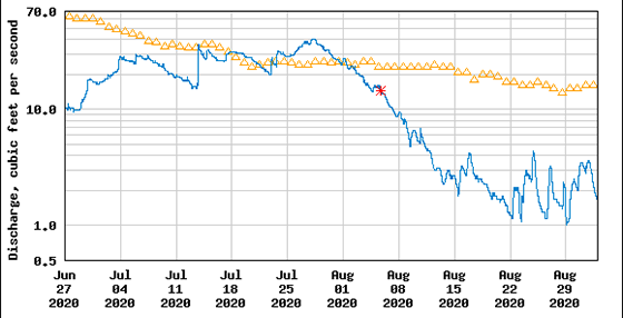
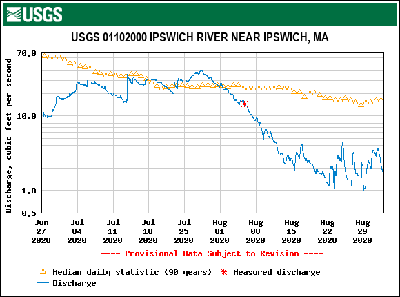
Climate projections predict longer stretches of record breaking heat and drought will be the new normal for New England summers. This was certainly true this year. Back in late June, the River’s flow dropped below the level record in June 2016, which was the beginning of the worst recorded drought in the River’s history. The arrival of summer thunderstorms in July brought a bit of help, but as the graph below from the USGS flow gauge shows, the relief was temporary. In August, the region had plunged back into a level 2 severe drought, with no substantial rains in sight.
The severity of the impact on the river was illustrated by footage of two Virtual Paddles held this year. On May 28th, volunteer Keith Attenborough paddled and live streamed on the river from Winthrop Street in Hamilton to Peatfield Street in Ipswich. This stretch flows beneath bridges, over a weir, along beautiful open space, and past our Riverbend headquarters before reaching Ipswich’s downtown. Though the river was below its usual spring levels in May, Keith had no problem navigating the route.
Keith paddle the same stretch again on August 13th and the difference was overwhelming. When the remote guided paddle began, Keith was already in his boat and a ways down from the put-in at Winthrop Street. This was because the low flow at the put-in required that he walk his canoe for some time before the water level was adequate to paddle. On the same day, Executive Director Wayne Castonguay was interviewed by Channel 5 News at Winthrop Street landing to discuss those very low flows (see clip below). These low flows are the result increasing water demand from a river already stressed by climate conditions. Even during drought, 30 million gallons per day are withdrawn from the river’s watershed.
Then Keith reached the private bridge just past Wintrhop St and the changes in the river since the May paddle, as the video at the top of the article shows, were staggering. On the May paddle, Keith had used this spot to illustrate how to ‘read the river’ and best steer your craft. On the August paddle there was no place to paddle under the bridge and Keith was forced to get out and drag his boat for several minutes.
Indeed, the August 13th Virtual Paddle would have been more accurately called a Virtual Walk. Beneath the bridge, below the weir, and for almost the entire stretch between the Mill St bridge and the railroad bridge just above Riverbend Keith had to walk rather than paddle. The extreme low flows just below Mill Street are especially disheartening, as this area has many critical riffles that are prime habitat for fish and macroinvertebrates.
It’s clear that the river needs our help more than ever. You can support the future of reliable water in three ways:
- Take the Greenscapes:Water for People pledge and get a FREE lawn sign to help spread the word that water is too precious to waste on grass. The more people who participate, the better chance our region has at creating behavior change that could transform the region!
- Ask your State Senator and Representative to support drought legislation.
- Support enhanced water conservation efforts in your town.
Join Ipswich River staff on a Virtual Paddle of the estuary on Thursday, September 10th and visit ipswichriver.org/droughtresponse to ask questions and learn more about our efforts to protect the future of reliable water.
I’ll also point out that the U.S. Geological Survey’s Aquatic Habitat Study of the Ipswich River indicated that flows of 52.5 cfs at the Willowdale gauge and 18.6 cfs at the South Middleton gauge are needed to sustain the river ecosystem. And flows this summer have been only 2% of those levels at times.
Rachel:. Well written article and well done video. Hope people start listening and acting to save our river and water supply. My concerns are more for the wildlife and how they are suffering. People are part of the problem and they are the wildlife are the innocents who suffer. Thanks for all your hard work to educate and find solutions.
Thank you, Donna! Yes, that pan shot in the video showed an area that should be critical habitat for fish and macroinvertebrates, but the flow is currently too low.